
How a Wayne County Property Search Moves
The WV Property Assessment Search is the main doorway for a Wayne County property search. It accepts an address, owner, district, map, or parcel. It also offers Basic, Appraisal/Sales, Advanced, and Prior Ownership modes. Address searches start from the Street Name field. The form supplies no separate box for the street number. Broad results respond well to narrowing. Use district, full parcel ID, map, parcel, sub-parcel, owner, or legal description.
Pin down the tax parcel first. Then carry the owner name, legal description, map-parcel, and deed reference to the County Clerk. Lay it beside the Sheriff's account and the plat. A Wayne County property search works best when the same parcel key turns up in every record. The mailing address, town label, or owner spelling may shift from one document to the next.
- Enter a known street name or owner in WV Property Assessment Search; set the county and district when known.
- Record the current owner, physical address, county, district, map, parcel, deeded acres, class, and appraisal columns from the result.
- Open the map link or Flood Tool only after the parcel match is clear; keep the full parcel ID with the record.
- Use the name, parcel, legal description, or deed book/page to request the related instrument from the County Clerk’s Document Inquiry.
- Check the Sheriff’s tax account by ticket or map-parcel, then request a certified copy from the custodian if legal reliance requires one.
Fields in Wayne County MapWV Search
MapWV offers several ways to sharpen a Wayne County property search. Most fields are optional. County and district set the context. The rest can stay blank until a likely parcel emerges. Dropdowns show only their available choices. Pick from what the screen displays rather than assuming hidden code lists behind it.
| Field label | Input type | Required? | Format or use |
|---|---|---|---|
| County | Dropdown | Not marked required | Select Wayne, county code 50 |
| District | Dropdown | No | Tax district narrows repeated names |
| Full Parcel ID | Text | No | Enter the complete root or GIS ID available |
| Owner Name | Text | No | Try entity and spelling variants |
| Street Name | Text | No | Street name search; no separate street-number field was visible |
| Map Number, Parcel, Sub-Parcel | Text | No | Enter known parcel components |
| Property Class, Tax Class, Land Use | Dropdowns | No | Options were not captured |
| Min/Max Land, Building, Total Appraisal | Numbers | No | Value ranges can narrow results |
| Min/Max Calculated Acres | Numbers | No | Map-estimated area filter |
| Min/Max Deeded Acres | Numbers | No | Area taken from deed data |
| Sale From / Sale Through | Date or year | No | Use a known time span |
| Min/Max Price | Numbers | No | Sale range filter; a result is not an appraisal |
| Flood Hazard | Dropdown | No | Advanced filter; options were not captured |
| Mailing Address | Text | No | Search the tax-bill destination |
| Deed Book, Page, Legal Description | Text | No | Recorded-reference or land-description clues |
| Building Year, Area, Structure Counts | Min/Max numbers | No | Improvement filters |
| Lines per page | Number or selector | No | Changes display size |
| Display legal description / GIS ID | Checkboxes | No | Adds cross-reference fields to output |
The MapWV assessment field screen helps when a Wayne County search starts from a deed book or a legal phrase instead of a modern address. Begin broadly there. Narrow only after the district and parcel come into view.
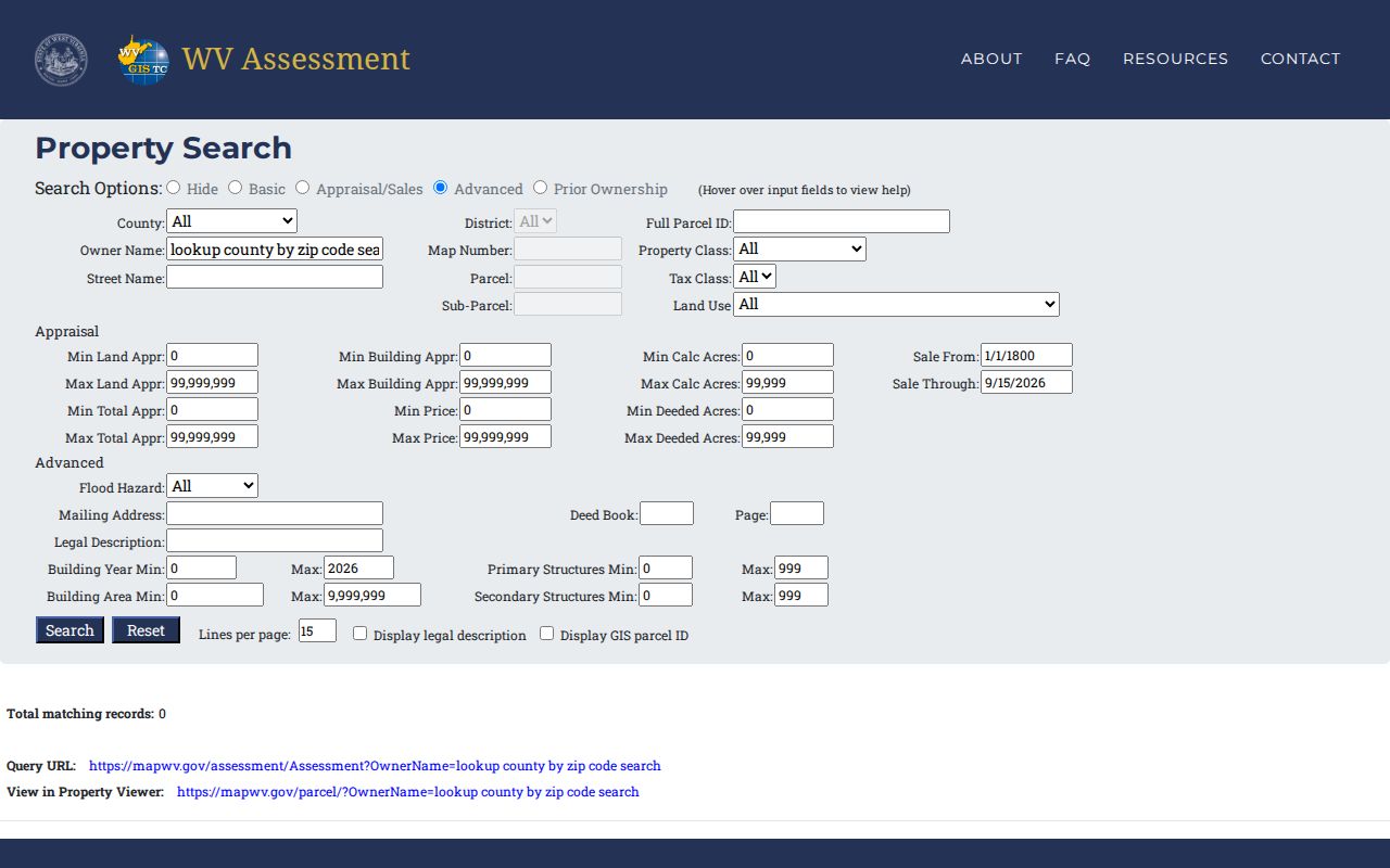
Each field on the MapWV screen links an address to its assessment entry. It does not establish title.
What a Wayne County Result Contains
A MapWV result for Wayne County opens with a root parcel ID, current owner, property address, county, district, map, parcel, and a map link. Flood Tool status, deeded acres, property class, land-use code, and tax class sit alongside building, land, and total appraisal figures. The detail page goes further. It adds the description, property owner, physical address, building information, cost values, and appraised values. These fields make parcel matching far easier. Still, the assessment result leaves out facts a buyer often wants, so treat it as one layer of the property record rather than the whole file.
| Current Owner | Name displayed on the annual assessment file |
|---|---|
| Property Address | Physical or situs label; mailing address is in parcel detail |
| Parcel keys | County, district, map, parcel, and sub-parcel fields |
| Appraisal fields | Building, land, and total appraisal, plus class and land use |
| Map and flood links | Open the related viewer and flood context |
| Missing from the sample | Last-sale price/date, exemption, owner mailing, and sketch were not visible in the table |
One sample result is a public parcel card naming the Wayne County Commission. It is not a typical home entry. Note the difference between a deeded-acre value and a calculated map area. Last-sale details, exemption status, and the owner's mailing address do not appear in the table. A building sketch does not appear either. Open the parcel report. Or ask the Assessor, instead of assuming the search result holds them. The Wayne County sample result on MapWV shows the blend of ownership, parcel, and acreage columns in one view. Class and appraisal columns appear there too.
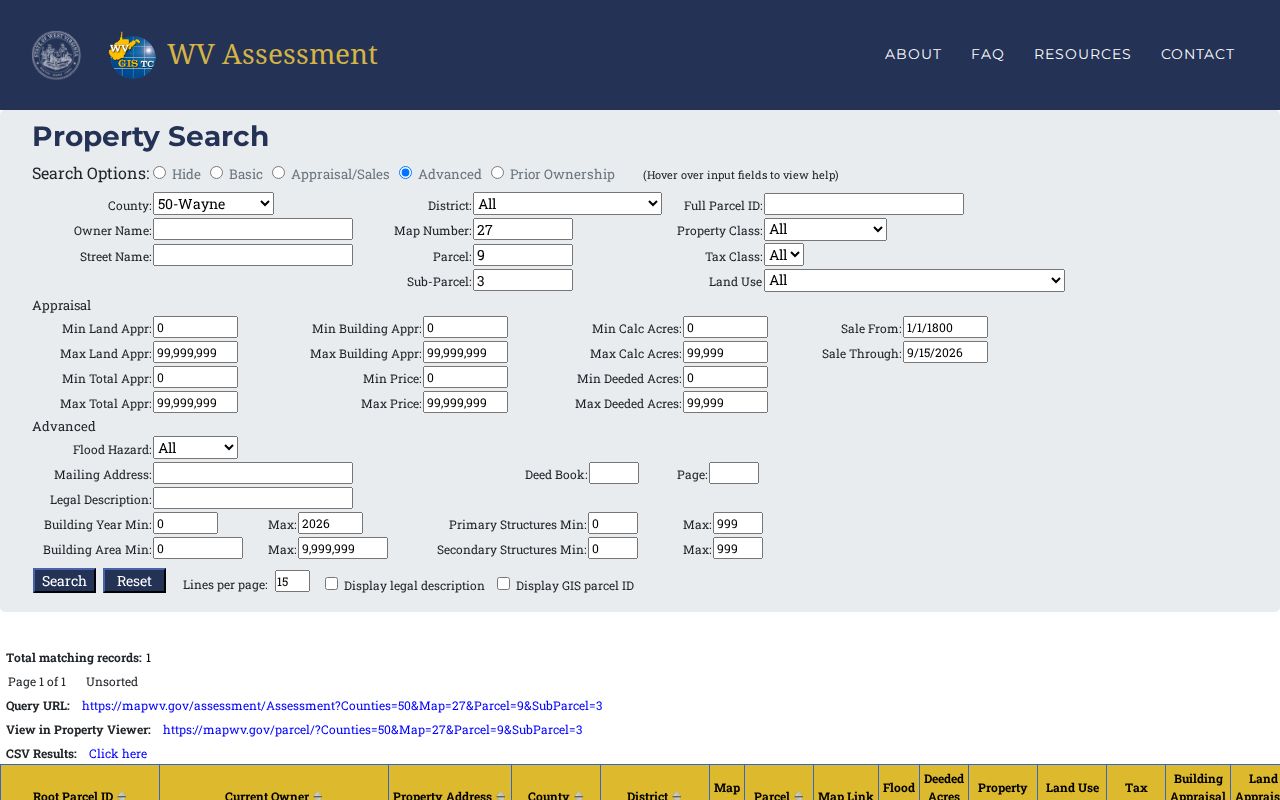
Read that sample as a field example from a public parcel card. It should not stand in for values of nearby homes in Wayne County.
Address, Owner, or Parcel in Wayne County
Each search key solves its own problem in Wayne County. A street-name search moves fast when the physical location is clear. But a long street can return a long list. An owner search can surface multiple holdings or a business grantee. Still, names repeat and entities file under legal names you may not expect. The parcel identifier settles disputes once another record supplies it. The table lays out these trade-offs for a Wayne County property search.
| Search Key | Best For | Where It Works | Watch Out |
|---|---|---|---|
| Street or address | Start with a known property | MapWV Assessment and WV Property Viewer | Street number is not a separate visible input |
| Owner or entity | Find other parcels under a name | Assessment Search; SOS entity search for an LLC clue | Variants, estates, trustees, and shared names |
| Full parcel ID | Match one assessment or map feature | MapWV, viewer, tax inquiry | Carry all available components, not a shortened label |
Not a title search. A Wayne County property search can point to an owner and recorded documents, but it does not establish that title is clear. For a sale or legal claim, review the deed chain with a qualified title professional.
- Owner of record
- The name on the current assessment or recorded instrument.
- Situs address
- The place where the parcel is physically located.
- Parcel ID
- The tax and map reference assembled from county, district, map, parcel, and other parts.
Wayne County Situs and Mailing Clues
MapWV leads with the physical property address, the situs. The parcel detail can also show the owner's address, which may point somewhere else entirely. That split explains an out-of-county tax bill or a notice mailed to an estate representative. It never proves the mailing recipient occupies or controls the land. Wayne County records draw this line for a reason.
Hunting a house or building? Record the situs. Chasing a bill or ownership notice? Compare the mailing address with the named owner of record. For a recent sale, remember that the July 1 annual file freeze can leave both the name and address a step behind the deed. The two address fields answer different questions, so keep them apart in your notes.
Note: A mailing address may point outside Wayne County while the tax parcel remains inside it.
Wayne County Appraisal and Sales Filters
The Basic, Appraisal/Sales, Advanced, and Prior Ownership modes each refine a Wayne County assessment search differently. Min and Max fields for land, building, and total appraisal help assemble a range of comparable parcels. Acreage filters separate calculated acres from deeded acres. Sale From and Sale Through boxes, plus Min and Max price, appear on the screen, though the system does not promise a complete transaction history or a sale price for every transfer. Treat a filter match as a lead, not a chain of title.
Build a comparison set first, then inspect the documents behind a sale. The County Clerk's index start year and instrument fields do not surface here, so the assessment result cannot carry the full transfer trail alone. The Wayne County deed-record page explains how to verify the recorded chain through the County Clerk's deed records.
When a Wayne County Address Fails
A modern E-911 address rarely matches the route, town name, or land description in an older deed. When an address search stalls, try other fields instead. Use the owner, legal description, map, or deed book and page. Wayne town carried earlier names. It was once Trout's Hill, then Wayne Courthouse, then Fairview. A historic transfer may bear a label you do not expect. Property near Huntington, Ceredo, or Kenova needs extra care. Confirm the county and tax district there rather than trusting a mailing city.
If an online field still returns nothing, call the Assessor's real-estate or mapping desk. Bring a known deed or survey reference. Need an image of the record? Give the County Clerk a grantor, a grantee, a date range, or a parcel description. The clerk portal can be slow to respond. The clerk also publishes no official index starting year. A specific request beats guessing at a hidden filter every time.
Exporting a Wayne County Search
MapWV results come with built-in export tools. Results expose CSV Results and a query URL. A GIS map link and a view in the property viewer are included as well. The parcel viewer adds Export as CSV, Copy Link, Highlight, and Download KMZ. These options preserve a working set or reopen a map later. They do not turn a tax map into a boundary survey. A spreadsheet is not a certified record either.
Save each query with its date, county, district, and full parcel ID. Keep an assessor export separate from a deed copy, a tax bill, and a survey. The Assessor's annual refresh can shift owner and value details, while geometry sometimes lags behind. Record the source URL and capture date before comparing two results side by side. The WV Property Viewer is the map companion when a result needs geographic context.
A saved CSV is a working research list, not an official certified copy. Preserve the column labels and search conditions alongside it. A later export may carry new owner names, revised appraisals, or a changed parcel description. Someone who must reproduce the search needs the exact Wayne County selection and district. Include the owner or street term and the download date too. Keep private notes separate from the public assessor fields. That way an interpretation is never mistaken for county data.
When a result seems to be missing, vary one search key at a time. Try the parcel ID without punctuation, then with the complete suffix. Try a former owner when a deed has just transferred. Test a shorter street-name term if the full address is not indexed consistently. Never combine an uncertain owner name and parcel number into one guess. A clean search trail helps the Assessor's real-estate staff tell apart a spelling difference and an annual roll update. A mistaken tax district stands out the same way.